
Walking route
Raspaille forest.


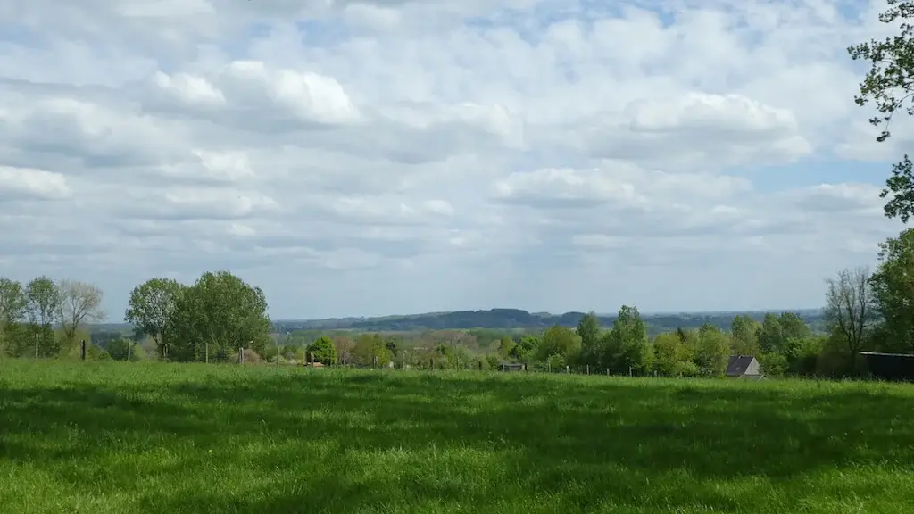
On the flanks of the Bosberg lies the Raspaille forest with an eye-catching carpet of colorful spring flowers and a legendary history. Once on the Bosberg you will be treated to a unique view of the valleys of Dender and Mark, but also on the Kluysbos. The valley of the Mark is a mosaic of alder and ash forests interspersed with hay fields and meadows. The Kluysbos, on the other hand, is one of the most beautifully developed source forests in the region.
Distance: 13 km.
Time: 3h30.
Grade: Moderate.
Type: Circular.
Gps Track: Yes.
Route description: Yes.
Wheelchair: Not suitable.
Dog: Allowed on leach.
Height gain: 225 meters.
Trail: Mainly unpaved.
Marking: Blue arrow and red square.
Hiking shoes recommended.
The Mark valley.
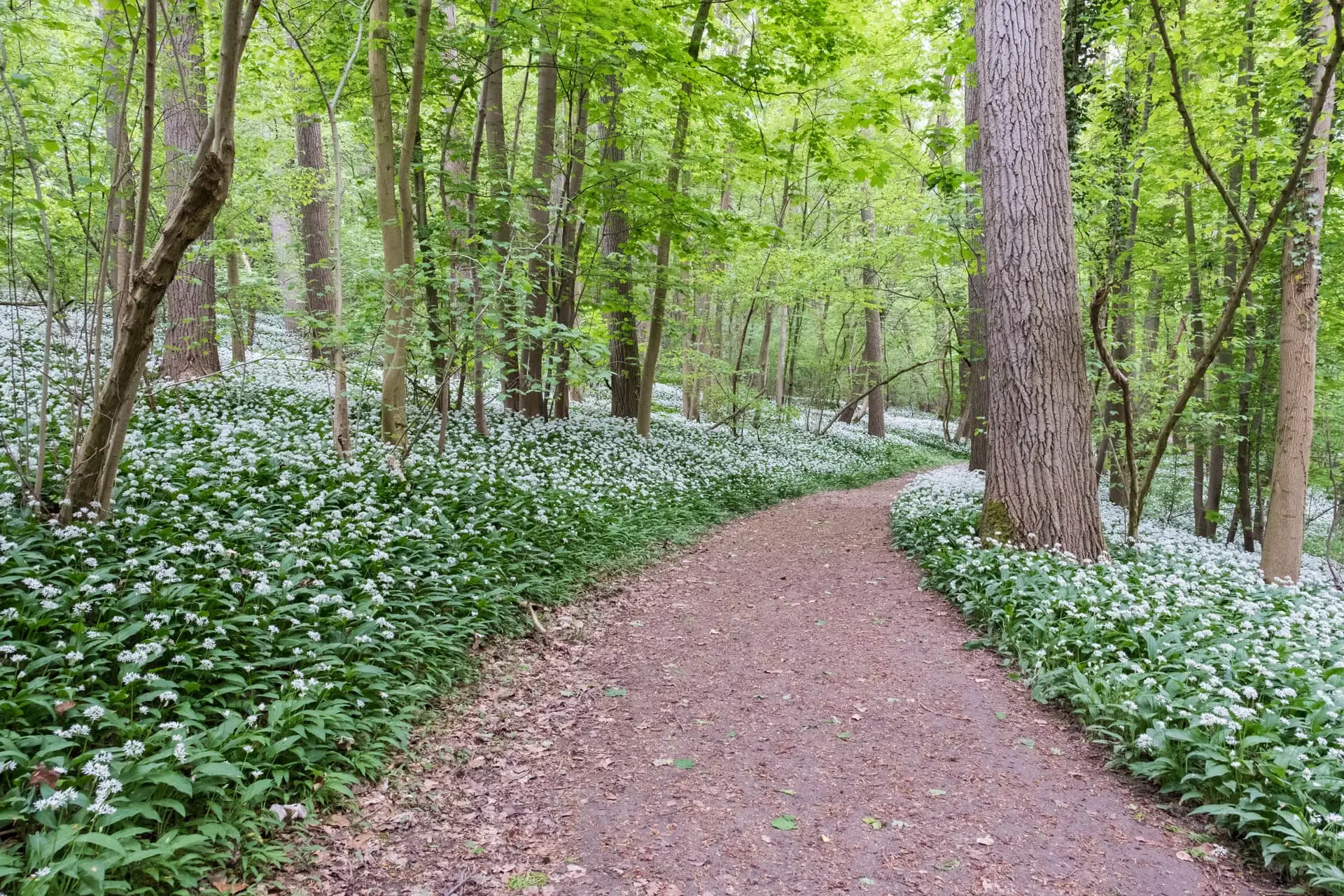
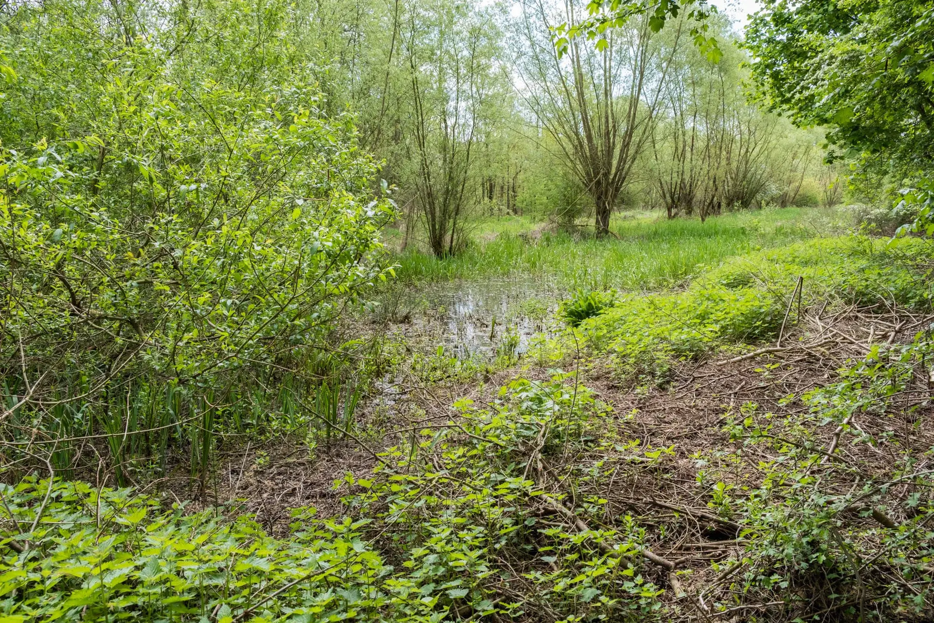
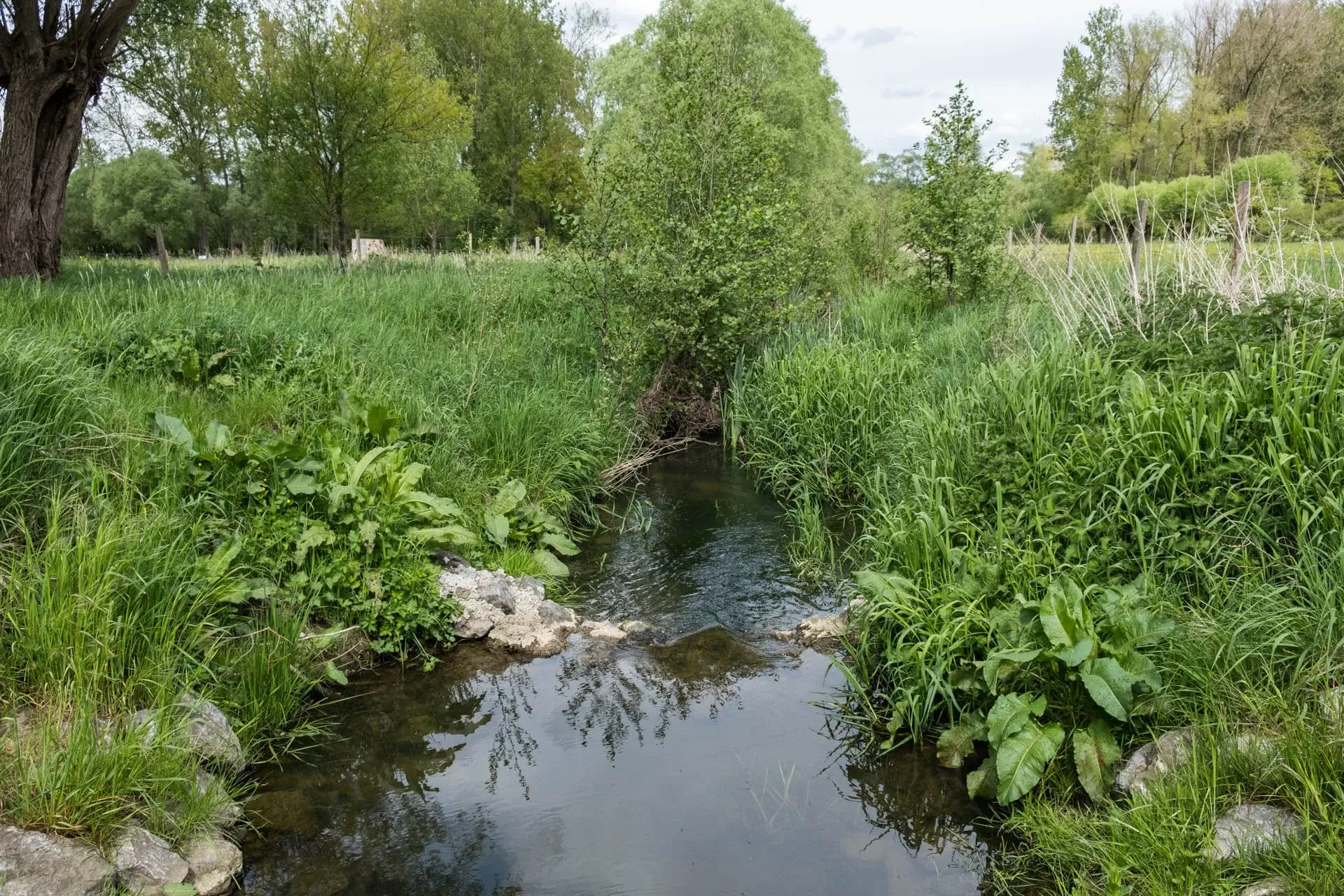
The walk leaves at the nature education center De Helix. Soon it goes towards the Raspaille forest on the flanks of the famous Bosberg. The Bosberg is the natural watershed line between the Dender and the Mark and that is why the plant wealth along the spring brooks is one of the most beautiful in Europe. Rare plants such as blueberries, forest orchids and beetle orchids are examples of this, but it is especially in the spring when weedweed, slender primrose, wild daffodil and dandelion turn the banks yellow, the spring brooks look absolutely fairy-like. A little later you will find beautiful carpets of white wood anemones and blue bluebells everywhere in the forest, then it is the turn of the wild garlic to roll out its white floral blanket. Traditionally, the Raspaille forest was the perfect retreat for a bunch of 'raspeel' or 'rapaille', the Old French name for the scum that made the neighborhood unsafe. It was not only the Ghent insurgents against Emperor Karel who assembled in 1540, the famous gang of Jan De Lichte also lurked around 1747. Although this is a nice story, Raspaillebos does not thank its name to the countless gangs of crooks. Historically less spectacular but etymologically more plausible is the Picardisch 'raspe', a reference to 'coppice' and the centuries-old logging tradition in and around the forest. Once you leave the forest you are on the legendary Bosberg. Here you have wide views over the Kluysbos and the valleys of the Dender and Mark. The substantial Congo mountain in Vollezele is also visible. The hill was at that time strewn with meager houses of miners or 'fossemens'. When they returned black from the coal from the Henengouwse mines, they were mockingly called 'Congolese' by the local residents. From the Bosberg it continues towards the Mark Valley, where you alternate with a mosaic of alder and ash forests with hay fields and meadows and decayed poplar plantations. The kingfisher digs his nesting in the steep banks of the Mark. The route then goes towards the Kluysbos, one of the region's most beautifully developed spring forests. Everywhere in the slopes, lime-rich water seeps from the bottom and spring streams are born. Especially in the spring you can enjoy the beauty of flowers, the giant horsetail and the hanging sedges here, but it will only become a real fairytale forest when the bluebells and wild garlic color the slopes blue and white. The last part of the walk goes through farmland, with beautiful views, look out for the church of Onkerzele, a real beauty on the horizon!
Download PDF for route description and map.
In wet weather the trails can be very muddy.
POI 1 - Raspaille forest.
On the flanks of the Bosberg, squeezed between the valleys of the Dender and the Mark, lies the Raspaille forest. The landscape combines the steep features of the Flemish Ardennes with the gentle slopes of the Pajottenland. The numerous paths, sometimes winding between dense forests or wide, flower-rich drifts, sometimes in the open landscape, invite you all year round to enjoy the colorful forest environment. From early spring until late spring, the forest turns yellow, white and purple with wild daffodil, wood anemone, periwinkle, wood hyacinth and wild garlic. The fragile spring green of the beech trees turns into deep green in the summer and becomes yellowish brown in autumn. Especially along the forest drift, the coppice management creates an ideal environment for rare woodland butterflies, such as elm, oak leaf and small kingfisher butterfly. Emperor's cloak, large weather-colored butterfly and forest-white also do darty summer dances. The fire salamander also has new opportunities through small interventions along the spring brooks. During the day, the salamander hides under stones, tree stumps or in old mouse holes. He does hunting at night. Only during rain can you see it during the day. In the forest, exotic species such as larch, poplar and American oak are replaced by local species. Then nature can conquer the forest again. Dead wood stays or stands because it is important for fungi, insects and animals that live in holes. Where it benefits the fauna or flora, the traditional management of chop or middle wood is restored. Forest can develop spontaneously in the fields and meadows around the forest. Grazing must ensure that this new forest never fully closes. Where hedges and willows adorn the landscape, grazing must stimulate the small-scale structure. The goal here is an open grassland with thickets. In the long run, a varied landscape will arise where the boundaries between the forest and its surroundings will fade away. As a remnant of the large Coal Forest, the Raspaille forest forms a whole with the Moerbekebos, the Karkoolbos and the Kluisbos. During the Second World War the area was almost completely cut down. Yet it was never a culture country, so that it retained its plant wealth. An old cobblestone road runs through the Moerbekebos, the Bosberg. In the uprisings of Ghent and other cities against the count's authority, forests played an important role. Many insurgents went into the woods during the burial repression. In 1382, during the first uprising, a number of refugees and exiles from Geraardsbergen, Dendermonde and Aalst became entrenched in the Raspaille forest, from where the area was plundered and burnt. The Raspaille forest would also have served as a shelter for the robber gang of Jan de Lichte.
Additional information:
www.natuurpunt.be.
POI 2 - 'Juffrouw' chapel.
The Juffrouw chapel known locally as "'t Iffraken" dates from before 1865. A drink from the well and a prayer for Apollonia was once good against toothache. The site used to be a Celtic prayer place. At the beginning of 2012, the dilapidated chapel collapsed. On 15 September 2013, the restoration was a fact. This fairytale site and this small monument deserve a place in the Raspaille forest.
No additional information.
POI 3 - Saint Paul chapel.
he hamlet of St. Paul owes its name to the chapel Saint Paul. The Saint Paul's chapel is located on the Kapelleblok , north of and close to the Pauwel farm. It was erected on a site that was already inhabited in the Gallo-Roman period. There appears to be no connection between the farm that probably stood there and the late medieval chapel, which was probably erected in the beginning of the 16th century. It is a brick building in late Gothic style. In the chapel, among other things, some 15th-century art objects are preserved. The local people assumed for centuries the following three legends: • The Saint Paul Chapel would have been an independent parish with its own priest, its own cemetery and its own income; • the Saint Paul Chapel would be a remnant of a small monastery, depending on the St. Adriaans Abbey in Geraardsbergen or the abbey of Beaupré in Grimminge; • the St. Paul's chapel would have been a chapel for lepers and the hamlet would have arisen as a result of a colony of lepers. What also popularly presupposes, we can say with certainty that the St. Paul's chapel already existed before the year 1068. The chapel is connected with a wonderful source, for our ancestors a holy place. Perhaps the creation of the Saint Paul Chapel should be situated in the time of the final evangelization and Christianization of our regions (ca. 800 AD).
No additional information.
POI 4 - Mark valley.
The Mark Valley is situated south of Geraardsbergen, on the border of three provinces: East Flanders, Brabant and Hainaut. The spring of the Mark is in Silly and ends at Geraardsbergen in the Dender. Hydrographically the valley belongs to the basin of the Dender. Despite the Mark's straightening, which did somewhat corrode the landscape, the drop in the water level remained relatively limited. The valley largely retained its individuality. Due to the absence of dredging work since the straightening, the river has even restored part of the damage. Due to accretion, the width is almost halved and the old meanders are recognizable again. Haylands cover a large area along the Mark. The forest areas along the banks of the Mark are mainly poplar plantations that were planted during the last decades. Hidden between the trees are old peat pits where in former times peat was mined as fuel. In the vicinity of the river there are some old peat pits that have been transformed into attractive water lakes thanks to the intervention of local nature lovers, where the yellow flag is in charge. Also the blue glidewort, waterviolier and duckweed have a good time. The blue heron, which occupies a small colony in the wettest part of the forest, is easy to see in the meadows. Who wants to see the kingfisher, which breeds in the banks of the Mark, must have a little more luck. The path along the Mark is the best place to spot this colorful bird. The Kluysbos is one of the most beautifully developed source forests of the region. Especially in the spring you can enjoy the beauty of flowers here. Dotterbloem, giant horse's tail and hanging sedges are the key players here. Rising higher on the slope, slim primrose, bluebell and wild garlic color the forest white and blue.
No additional information.


Walks East Flanders.


