
Walking route
Duivenbos.


Near the center of Sint-Antelinks is somewhat hidden in a bowl-shaped valley, the beautiful Duivenbos. An old spring forest, bordering a quiet area and surrounded by an unspoilt agricultural landscape. In spring you will find beautiful carpets of wild garlic and wood anemone.
Distance: 10 km.
Time: 2h30.
Grade: Easy.
Type: Circular.
Gps Track: Yes.
Route description: Yes.
Wheelchair: Not suitable.
Dog: Allowed on leach.
Height gain: 156 meters.
Trail: Paved and unpaved.
Marking: None.
Hiking shoes recommended.
Buyse mill.
The church of Sint-Antelinks is the starting point of this walk. The church tower of the Stint-Gertrudis church dates from 1847. There is an orientation table in the cemetery. It offers a view over the Beverbeek valley and the Dender valley. In clear weather, the Oudenberg in Geraardsbergen is also visible, known from the wall of Geraardsbergen. The route is on paved, traffic-calmed roads and partly on unpaved paths. On the way you have beautiful views to all corners of the region. For centuries, two farms dominated the agricultural activity in Sint-Antelinks. The "Hof te Roeselare", already mentioned in 1002, was owned by the Norbertines of Ninove. The "Hof te Ransbeek" belonged to the Nijvelse abbey. In the 12th century this place was still called "Ransbecca". From where the later name comes, is not immediately clear. The site of the Buyse mill is also worthwhile.
Download PDF for route description and map.
Some paths can be very muddy.
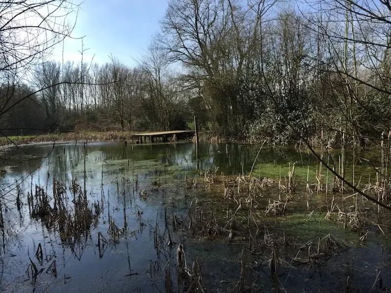
POI 1 - Duivenbos.
The "Duivenbos" is hidden in a bowl-shaped valley in the hilly landscape in the Flemish Ardennes. The eastern part is the oldest. Here, water is bubbling up to the surface. They are real sources. Over time, nature in this source area has evolved into a forest. The core of the Duivenbos is very wet. In some places, water drainage is slow. This creates marsh forests. The surrounding grasslands are rugged, leaving the meadows. Blackberries scramble over the herb layer. Donkeys or cattle graze here and keep the herb vegetation open. The Duivenbos is an important area in the Flemish network of nature reserves and is therefore part of the Flemish Ecological Network. Possibly the name 'Duivenbos' is a corruption of Devils forest. However, the area used to be important for the village community of Sint-Antelinks. During the war the forest served as a shelter. But they also went there for wood and did small-scale agriculture. The small landscape elements that remain from that time are ecologically very useful. You can see fragments in and around the nature reserve: hollow roads, roadsides, wood edges, hedges, pools, ditches, and slopes. The fountain along the red walk was formerly used by villagers to collect water. Nowadays there are toads and frogs living.
Additional information:
www.natuurpunt.be.
POI 2 - Buyse mill.
Outside the village was a wooden windmill from 1427. The in 1944 protected windmill Ter Rijst or Buyssemolen (locally named after the last miller family) collapsed in the summer of 1976. Restoration plans were drawn up shortly after the collapse by Ro Berteloot, architect-molinologist. In 2005 new plans were made to reconstruct the stake mill. In the autumn of 2007, restoration work was put out to tender and a year later, on 21 October 2008, work was started. With a special transport, the mill was transferred from West Flanders to Sint-Antelinks.
Additional information:
www.herzele.be.


Walks East Flanders.


