
Walking route
Through the Doldersummerveld.

Through the Doldersummerveld.
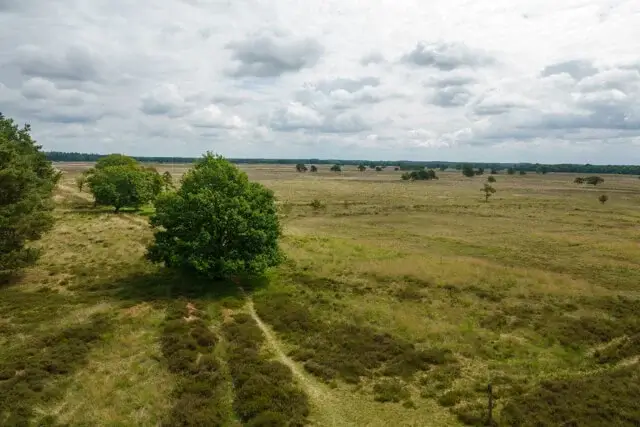
This walk takes you through the Doldersummerveld in the Drents-Friese Wold National Park. The Doldersummerveld is a vast, wet heathland reserve situated on the flank of the Vledder and Wapserveensche Aa river valley. The nature reserve is known for its expansive heathlands, which are bright yellow in summer thanks to the flowering bog asphodel and a beautiful purple in autumn thanks to the heather.
Distance: 12.5 km.
Time: 3h30.
Grade: Moderate.
Type: Circular.
Gps Track: Yes.
Route description: Yes.
Wheelchair: Not suitable.
Dog: NOT Allowed.
Height gain: Flat.
Trail: Paved and unpaved.
Marking: Purple post and red arrow.
Hiking shoes recommended.
Wasperveld.
The walk first traverses the vast Drenthe heathland of the Wasperveld. You'll pass a war memorial from World War II. This modest monument commemorates seven young men who were executed here by the Nazis after escaping from the labor camp in nearby Vledder. The route detours through the wet grasslands of the Vledder stream valley. You return via the hamlet of Wateren, reaching the Doldersummerveld. The route cuts straight through this beautiful heathland with expansive views. You might even encounter grazing Drenthe heath sheep or Scottish Highland cattle. The walk continues through birch and pine forests that surround the Doldersummerveld heathland. You'll walk along the edge of the forest for a considerable distance, passing old cart tracks, made visible by the placement of old cart wheels. From the early Middle Ages until the 18th century, carts, carriages, and coaches followed these routes. Over time, this created a pattern of eroded depressions in the heathland. A little further on, you'll come to the 13-meter-high lookout tower, also known as the Polish lookout tower. From the tower, you have a magnificent view of the vast heathland. You continue your walk through the dense forests of Doldersummerveld and a grassy path between Drenthe fields. Once you reach Huenderweg, turn left to finally arrive at the sheepfold and the Huenderhoeve Information Center.
Download PDF for route description and map.
During wet periods the paths can become muddy.
Well marked.


Walks Drenthe.


