The second stage from Aarle-Rixtel to Lieshout passes through the Groot Overbrugge estate, the Croy estate and the Molenheide.
Distance: 13 km.
Time: 3h00.
Grade: Moderate.
Type: Point to point.
Gps Track: Yes.
Route description: Yes.
Wheelchair: Not suitable.
Dog: Allowed.
Height gain: No info.
Trail: 72% unpaved.
Marking: See PDF route description.
Hiking shoes recommended.
Advertisement.
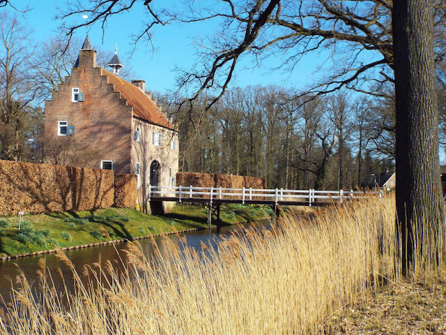
Croy Estate.
Overbrug is an old hamlet in the municipality of Helmond where a farm on De Overbrug is mentioned in writings as early as 1427. The stage goes through the part of the Groot Overbrugge Estate that is located west of the Schevelingse Loop on the territory of Laarbeek. The area consists of small swamp forests and wet grasslands. After leaving the estate, the Goorloop is followed to Croy Castle, the oldest parts of which probably date from the mid-fifteenth century. In 1472, a certain Rutger van Erp owned a castle and farm here. In 1477 he sold the castle to Jacob van Croy, the namesake of the castle. Later, several noble families inhabited and further expanded the castle. The last noble family was the Van der Brugghen family, of which Freule Constance van der Brugghen was the last noble resident. After her death in 1872, she left the castle to a foundation under the name of Faith, Hope and Love, which stated that it should be furnished as a home for poor old men and women from Stiphout and Aarle-Rixtel. This foundation still manages the castle and surrounding estate. The Molenheide, part of the Stiphouts Forests, is originally a heathland area that was later planted with coniferous wood. The Molenheide owes its name to a windmill built in the 14th century southeast of Lieshout in a small heathland area. The oldest known mention of the name Molenheide for that relatively small area can be found in a 1587 alderman's deed, which mentions a 'groesveld on the spot named aende Moelsheijde'. In the centuries that followed, the name Molenheide was used for the current forest area south of Lieshout.

Download PDF for route description and map.