In Terneuzen, the water is always close by. The discharge channel, the Otheense creek, the channels in the nature reserve Margarethapolder and the Westerschelde, you will all pass or cross it. The area fought against the water for centuries.
Distance: 6 km.
Time: 1h30.
Grade: Easy.
Type: Circular.
Gps Track: Yes.
Route description: Yes.
Wheelchair: Not suitable.
Dog: Allowed.
Height gain: Flat.
Trail: Mainly unpaved.
Marking: Walking nodes.
Hiking shoes recommended.
Advertisement.
Fight against the water.
The route starts at node 25 west of the Otheense creek. Sixty years ago a different world started here, according to an old Terneuzen resident. Noten, the hamlet on the other side of the creek, was in the perception of the little boy, miles from Terneuzen. Nowadays it is no longer a world tour, because you can easily reach the other side via the pedestrian bridge. Noten, the common name of Othene, has a much longer history than Terneuzen. A prehistoric ax proves that people had already resided here long before Flemish abbeys in the early Middle Ages reclaimed the salt marshes and mud flats and founded a chapel there. Othene was then on an island together with the villages of Aendijcke and Zaamslag. In the early thirteenth century it disappeared in the waves. In 1586, after the village was rebuilt, the States sacrificed Othene on the water. They crossed the dikes, so that the Scheldt became inaccessible to Spanish troops. The current Otheense creek was created through the hole in the seawall. Nowadays there is a beautiful walking path along this creek, which leads to node 28, on the border of old and new Othene. The contrast between the new building on one side and the Veld- en Kreekzicht farm on the other is great. Straight through the district, via the Laan van Othene, Ooievaar and Margarethaplein, you will arrive a little later at the iron entrance gate of the Margarethapolder nature reserve. A polder named after one of the craftsmen of Zaamslag and which was flooded until the early nineteenth century. As soon as you pass under the gate, civilization is suddenly far away. Even car traffic on the Reuzenhoeksedijk is not noticeable. The further you walk, the narrower the path. For a shorter tour you go at node 29 to 21. The detour continues via 24, 23 and 22. Just before node 24 you cross a water. Binoculars come in handy here, because two spoonbills spoon up fish on the mud flats. Along the Knapzakweg you can choose again: either further along the narrow grassy path or along the quiet asphalt road. At node 21 you are at the foot of the Scheldedijk. The seawall is now strong enough to withstand a super storm. That was different in 1953. Then the dyke broke at Othene. With all their might it was prevented that Terneuzen and East Zeeuws-Vlaanderen would be flooded. The last part of the route follows the Basalt promenade, towards the pumping station. At node 20 the route bends back to the drainage canal. Here you cross and take the willow path between the lock and the church. The cormorants regularly dry their plumage on posts in the water. But even without them it is a worthy ending.
Download PDf for nodes to follow.
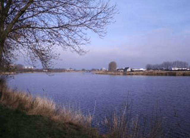
POI 1 - Otheense Creek.
The Otheensche Kreek is a fairly wide creek in Zeeuws-Vlaanderen, named after the village of Othene that has since been swallowed up by Terneuzen. The northern part of the Otheensche creek is currently located in the city of Terneuzen. The Otheensche creek once started as the Notense Geul, an outlet of the Honte. The Otheensche creek has become increasingly sweeter over the years and is currently a reservoir for fresh water. The creek covers about 100 acres and is an average of three meters deep. Because the creek is seen as bathing water, there is more control over the quality of the water, which only increases the quality of the water, which also benefits the fish stock. In this way, the creek is also suitable as fishing water. The north side is surrounded on two sides by Terneuzen. On the east side are Othenepolder, Othen (Noten), Rietlanden and the Kraaglanden. Noten is the former village of Othene that lies entirely in the new district of Othene. Othenepolder, Rietlanden and Kraaglanden are three new districts of Terneuzen. In the Rietlanden district, many houses have been built along dug canals that end in the Otheense creek. The Kraaglanden is still under development and should become an exclusive living environment with a lot of greenery in mind. The green should then merge into the creek. Between the Othenepolder district and the Serlippenspolder district, there is a drainage lock that serves to discharge water from the Otheensche Creek into the Western Scheldt. Until the 1960s, a drainage canal ran west through the Serlipenspolder and between the sea dike and the Noordpolder to Terneuzen, where the water was discharged into the Western Scheldt. Due to the expansion of Terneuzen with the Serlippenspolder district towards Othene (Noten), the canal was largely filled in. Only the part in the Noordpolder district has been preserved. On the west side of the creek are the neighborhoods Serlippenspolder, Katspolder, Zeldenrust and De Kraag. A park has been created between the creek and the latter neighborhoods, with lots of reeds along the water and the opportunity to fish or swim. Swimming is allowed everywhere except in places indicated by signs. There are also two small marinas for small pleasure boats. One in the Serlippenspolder, which is no more than an inlet and a landing stage, and one in the Katspolder. The latter port is a real marina where the boats of the local scouting are also moored.
No additional information.
POI 2 - Nieuw-Othenepolder.
The Nieuw-Othenepolder is a polder to the east of Terneuzen, belonging to the Zaamslagpolders. After the Otheense Kreek was dammed in 1650, a salt marsh grew between the Serlippenspolder and the Margarethapolder. At the end of 1846, a permit was granted for its reclamation. This coincided with the construction of a discharge channel, of which the Otheense Kreek was part. The 54 ha polder was completed in 1848.
No additional information.
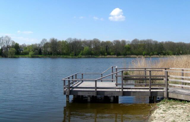
POI 3 - Scheldeboulevard.
From the point "Terneuzen - Scheldeboulevard" you can enjoy a magnificent view.
No additional information.